


وصف لـ GPS on ski map
Maprika is the best mapping solution for ski resorts, parks, and campuses.
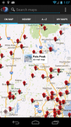
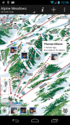
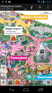
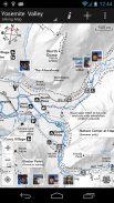
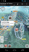
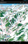
Maprika uses GPS to put a "You are here" sign on "paper" maps, just like the ones you get at ski resort ticket windows or park information booths.
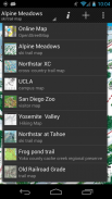
• Navigate on more than 6000 maps of ski resorts, hiking and biking trails, theme parks, and university campuses
• Maprika maps are saved to the phone's memory, allowing for use in out of service areas.
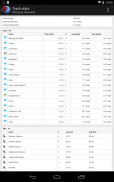
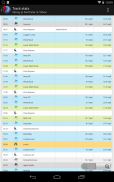
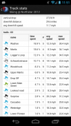
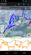
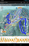
• Record GPS tracks and show them real-time; export tracks and view them on your computer
• Share your location with friends
• Set meetings with your friends by pointing the place on a map
• Make your own maps and share them with the Maprika community
• See local weather, snow reports, and Twitter feeds for resort maps, find nearby attractions
</div> <div jsname="WJz9Hc" style="display:none">Maprika هو الحل الأفضل رسم الخرائط لمنتجعات التزلج على الجليد، والمتنزهات، والجامعات.
يستخدم Maprika GPS لوضع "أنت هنا" علامة على خرائط "ورقة"، تماما مثل تلك التي تحصل في شبابيك التذاكر منتجع للتزلج أو أكشاك المعلومات الحديقة.
• انتقل على أكثر من 6000 خرائط لمنتجعات التزلج على الجليد، والمشي وركوب الدراجات، والمتنزهات، والجامعات
• يتم حفظ الخرائط Maprika إلى ذاكرة الهاتف، مما يسمح للاستخدام في الخروج من مناطق الخدمة.
• سجل GPS المسارات، وتبين لهم في الوقت الحقيقي. مسارات التصدير وعرضها على جهاز الكمبيوتر الخاص بك
• مشاركة موقعك مع الأصدقاء
• اجتماعات مجموعة مع أصدقائك من خلال الإشارة المكان على الخريطة
• تقديم الخرائط الخاصة بك ومشاركتها مع المجتمع Maprika
• انظر الطقس المحلي، وتقارير الثلج، و Twitter لخرائط المنتجع، والعثور على مناطق الجذب السياحي القريبة</div> <div class="show-more-end">
GPS on ski map - إصدار 3.70
(23-02-2024)GPS on ski map - معلومات APK
نُسخة APK: 3.70الحزمة: com.maprikaتطبيقات من الفئة نفسها
قد يعجبك أيضًا...


